
 A leading international subscription data-on-demand service provider, focusing on environmental, infrastructure, business and policymaking data with emphasis on the Arctic and the Northern Region.
Provider of expert data and consulting on request services focusing on specialized collection, processing, evaluation, interpretation and presentation of data, including educational and science communication products and tools with related consulting services for business, policymakers, educators and alike.
ArcData provides the following data services:
- Data collection,
- Format conversion,
- Statistical processing,
- Temporal and spatial redistribution plotting.
Data services can be presented as:
- Statistics, analysis and policy reports,
- Through online mapping system with layers of client's choice and integration and interactive comparison options,
- Animations,
- “Tailor-made” Data packages.
ArcData provides extensive data, data services and consulting, including:
- Arctic general statistics,
- Arctic environment and ecosystem, (including weather, tidal and sea ice)
- Arctic indigenous people,
- Arctic resources and energy, including renewable energy,
- Arctic Business and Arctic Policies
- Arctic science, observations and projects,
- Arctic knowledge and culture.
- Education – courses and virtual tools
- Science Communication
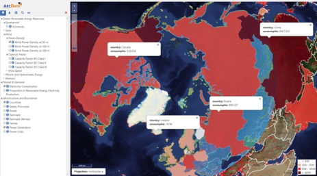
ADMS Technical Overview
The ADMS mapping and data management system is a Web-based GIS application that is general and implemented mainly through client-side Web programming.
All layers are either connected through web-services and/or hosted on a Geo Server, owned, controlled and hosted by ArcData and are shared between different instances of the system.